Back جراند كانال ARZ গ্র্যান্ড ক্যানেল (ফিনিক্স) Bengali/Bangla Grand Canal (kanal sa Tinipong Bansa, Arizona) CEB Grand Canal (Arizona) German
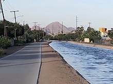
 Grand Canal at 3rd Avenue facing east | |
| Location | Phoenix, Arizona |
|---|---|
| Country | United States |
| Specifications | |
| Length | 23.5 miles (37.8 km) |
| Maximum height above sea level | 1,160 ft (350 m) |
| Navigation authority | Not navigable |
| History | |
| Original owner | Grand Canal Company |
| Geography | |
| Direction | Westward |
| Start point | Washington Street and North Center Parkway |
| End point | West Bethany Home Road and North 107th Ave. |
| Beginning coordinates | 33°26′21″N 111°56′47″W / 33.4391°N 111.9463°W |
| Ending coordinates | 33°31′22″N 112°17′27″W / 33.5227°N 112.2909°W |
The Grand Canal is a major canal in central Maricopa County, Arizona in the United States, that aided in the early agricultural development of Phoenix, now running through many of the historic neighborhoods in central Phoenix.[1] The canal now serves to feed municipal water systems in the Valley of the Sun as well as neighborhoods that practice flood irrigation for landscaping.[2]
- ^ "History of Phoenix's Grand Canal". cronkiteworks.asu.edu. Archived from the original on 2018-08-16. Retrieved 2019-10-21.
- ^ "How irrigation works | SRP". www.srpnet.com. Retrieved 2019-10-21.
© MMXXIII Rich X Search. We shall prevail. All rights reserved. Rich X Search